-----------Wednesday Hikes----------
WEDNESDAY Nov 23
NO HIKE SCHEDULED - NO LEADER AVAILABLE
WEDNESDAY Nov 30
NO HIKE SCHEDULED - NO LEADER AVAILABLE
WEDNESDAY NO. W1104-492 Dec. 7
Annual Cookie Hike, Bent Creek Ramble *8:30 AM
Hike 7, Drive 10, 1200 ft. ascent, Rated B-B
Ken and Carol Deal, 828-281-4530, cnkdeal@charter.net
P400 *Only meeting place: Ingles parking lot on NC 191 across from Biltmore Square Mall. Moderate loop hike in the Bent Creek area. We will start from the parking area for Cold Knob Road (FS 479H off Bent Creek Road beyond Lake Powhatan). Using a variety of short sections of trails, we will hike up to the MST, follow it past Sleepy Gap, and descend by the Stambaugh Trail to the Lake Powhatan picnic area for lunch and a cookie feast. Bring cookies to share. The afternoon walk back to the cars is approximately 2 miles. Topo: Asheville; also NatGeo map #780 and Bent Creek Trail Map.
ALTERNATE HIKE
WEDNESDAY NO. W1104-i Dec. 7
Cookie Hike, shorter version *10:00 AM
Hike 4, Drive 10, Rated C-C
Diane Stickney, 828-254-9054
*Only meeting place: Ingles parking lot on NC 191 across from Biltmore Square Mall. We will start on the Lake Powhatan Connector and hike to the picnic area to meet the other group for lunch and to share cookies. After lunch we will return to the cars.
WEDNESDAY NO. W1104-216 Dec. 14
Sams Gap to Devil Fork Gap 8:00 AM
Hike 9, Drive 90 1900 ft. ascent, Rated A-A
Janet Martin, cell: 502-494-9309, jaykaymartin@msn.com
Follow the AT south from Sams Gap to an overlook at High Rock, and continue to Rice Gap, Lick Rock, Sugarloaf Gap and end at Devil Fork Gap. The ridge along the state line provides views into Tennessee and North Carolina with the south bound hiker actually traveling north. Car shuttle. Topo: Sams Gap
Seventeen hikers enjoyed a clear, sunny day with extensive views. Views of the crest of the Black Mountains and the Roans were especially impressisve.
A special thanks to Danny Bernstein for sharing her knowledge about the current forest management program with suppressed burns and the history of the area. Thanks to Tom Sanders for ably serving as sweep. The hike was delightful respite from the holiday bustle. Janet Martin
WEDNESDAY NO. W1104-182 Dec. 21
Green River Cove Trail 9:00 AM
Hike 6.7, Drive 73, 1000 ft. ascent, Rated C-B
Marcia Bromberg, 828-505-0471, mwbromberg@yahoo.com
This is a scenic winter hike along the lovely Green River. We'll hike to the big rocks in the river at the end of the trail, and return by the same route. This hike includes a few steep, but short uphills. Second meeting place: Cracker Barrel at Exit 53 off I-26 at 9:30 AM. Topo: Cliffield Mtn.; also Green River Gamelands Map
WEDNESDAY NO. W1104-589 Dec. 28
Shut-in Trail & Lake Powhatan loop 10:00 AM
Hike 7, Drive 15, 1200 ft. ascent, Rated B-B
Bob Hysko, cell: 828-243-3630, rhysko@yahoo.com
P400 This will be a shorter version of #589, a loop hike that follows the MST west, then descends Stambaugh Trail, skirts Lake Powhatan and finishes on the Bent Creek Trail. Second meeting place: BRP French Broad Overlook at 10:15 AM. Topos: Asheville , Dunsmore Mtn. , also NatGeo. map #780 and Bent Creek Trail Map
----------Weekend All Day Hikes----------
BACKPACK NO. B1104-739 Nov. 25-27
AT from Wallace Gap to Deep Gap *7:30 AM
Hike 21.3, Drive 82, 4640 ft. ascent, Rated AA-AA+
Paul Benson, 828-251-1909, pdbenson@charter.net
*Meeting place(s) to be arranged with leader. Wilderness area, so group size is limited to ten. Contact leader to reserve a space. This two-night, three-day backpack will follow the AT southbound through the remote Southern Nantahala Wilderness Area, and skirt the Big Indian Mountain Treasure addition to the Wilderness Area. The hike will be moderate, but winter backpacking experience is desirable. We should be treated to plenty of spectacular views from our ridgeline walk around the headwaters basin of the Nantahala River. We'll climb Standing Indian Mountain, highest point south of the Great Smokies. Starting at Wallace Gap, we'll cover 6.4 miles to the Big Spring shelter on the first day. The next day we'll hike about 10 miles to our camp at Beech Gap, and the final day will be about 5 miles to Deep Gap. Ten-mile car shuttle. Topos: Rainbow Springs, Hightower Bald; also ATC Nantahala Natl. Forest-Bly gap to Fontana Dam and USFS Southern Nantahala Wilderness maps
A group of five stared at Rock Gap on a beautiful fall day for the short (5 mile) uphill hike to Big Spring Gap where we found a very nice camp site near the shelter. After setting up camp we explored the nearby Albert Mountain lookout where we were rewarded with 100 miles views! After dinner a small but very happy group of us headed back up for a look at the stars (100 light-year views), which were spectacular, especially for this city boy. Next day we said goodbye to 2 of our group who headed back out to Rock Gap, while the 3 remaining hikers continued a 10 mile rolling hike under cloudy skies to the beautiful open woods of Beech Gap, where we had the gap to ourselves to enjoy dinner and a nice campfire. About midnight the expected rain showers moved in, but stopped sometime before dawn, so we were able to enjoy breakfast and get packed. This final day's hike was 3 miles up to the summit of Standing Indian Mountain (the highest point south of the Great Smokies) which took us about an hour and a half under periodic light rain and gusty high winds. Unfortunately the summit view was only of cloud, but the misty, gusty wilderness environment was majestic in its own way. I was particularly happy when I set foot on the summit because it completed my goal of hiking all of the AT in NC! We then headed down the scenic and rugged Lower Ridge Trail back to the Standing Indian Campground arriving at about 1:30 awesome trip and a great group! Paul Benson 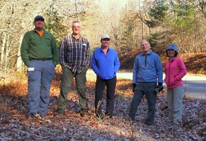
SATURDAY NO. A1104-584 Nov. 26
Butter Gap Loop 9:00 AM
Hike 9, Drive 75, 2000 ft. ascent, Rated A-AA
Les & Catherine Love, 828-658-1458, lesrlove@charter.net
P400 We'll follow parts of the Cat Gap Loop, ALT, and all of the Butter Gap trail through the beautiful Grogan Creek watershed to Picklesheimer Fields. Second meeting place: Pisgah Fish Hatchery at 9:40 AM. Topos: Shining Rock, Rosman; also NatGeo. map #780
There were 9 of us for a pretty day to hike up Cat Gap Loop and on to the base of Cedar Rock for a protected lunch from the wind. Toward the end of the hike, we saw at least 20 buzzards watching us from their perches and then found a nice display of Oriental Beauty Berry. Les & Catherine Love
SUNDAY NO. A1104-409 Nov. 27
Jones Gap - El Lieutenant Loop 8:00 AM
Hike 10.3, Drive 95, 2200 ft. ascent, Rated A-AA
Carroll Koepplinger, 828-667-0723, carrollkoepp@bellsouth.net
Starting at Jones Gap State Park (NOTE: $2 entry fee per person), we will hike up the Jones Gap Trail along the Middle Saluda River, then the Bill Kimball Trail up through the boulders and forest, then a rock scramble to climb up and over the granite face of El Lieutenant. We'll continue on the Kimball trail, walk a short portion of US 276 to our return loop on the Tom Miller and Jones Gap Trails. Additional meeting places: NE corner of parking lot at Cracker Barrel at Exit 53 of I-26 at 8:30 AM; also Jones Gap State Park parking lot at 9:00 AM. Topos: Cleveland, Table Rock; also Mountain Bridge Wilderness map
With the weather reports not being very favorable seven (not to be deterred) hikers, left the trailhead at 9:15 am with overcast skies. Beginning on the Jones Gap trail we ambled to the base of El Lieutenant. After a short break we proceeded to climb the 1,700 ft ascent to the top. We all made it in good shape with no slips or slides. This is probably one of the most technical climbs on the CMC data base. We then enjoyed lunch in a secluded, out of the wind spot, on top with a much deserved rest.
Continuing on the loop returning to the Jones Gap trail with a very short aside to see the Jones Gap Waterfall, which was admired by all. We returned to the trail head shortly before 4:00 pm. About 3 miles from the end of the hike it started to rain lightly and we all got our rain gear on. This brief sprinkle stopped and within 10 minutes we packed away the rain gear and enjoyed the entire hike in about 60 degree weather without any other rain whatsoever. One member on the hike joined us from Louisana, welcome Donna! 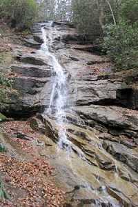
 Photos by Danny Bernstein
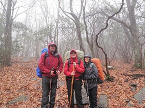
SUNDAY NO. A1104-335 Dec. 4
Bald Mtns. via Big Creek (Mountain Treasures hike #2) 8:00 AM
(strenuous)
Hike 10, Drive 96, 2280 ft. ascent, Rated A-AA
Ted Snyder, 864-638-3686, tedsnyderjr@bellsouth.net
The ridge of the Bald Mountains forms the NC-TN state line where we are venturing. A roadless area of about 23,000 acres falls on both sides of the ridge. This is one of the largest unprotected mountain forests in the two states. A warm-up climb takes us to the ridge where we join the AT. The AT takes us over Big Rocks, or Big Butt (4838 ft.) with wide views. Our descent is along Dry Creek which runs mostly underground. A short road walk closes the loop. Topos: Greystone, Flag Pond; also NatGeo map #782
Seventeen hikers signed in for the Bald Mountains expedition. It was a long, strangly line at all times.
Weather was not propitious. A layer of thin clouds blocked the sun. As we neared the ridge at the end of the first hour, the roaring of the wind in the tree tops was a new warning. We estimated it at twenty miles per hour when we first climbed into it. At lunch, at Big Butt, all but two hikers took refuge in the woods rather than relax on the rocks with their usual inspiring view. By mid-day the temperature was up to 50 degrees, F. but the wind chill was down around freezing. By about 2:00 p.m. however, the clouds had cleared and we had a cozy time the rest of the day.
Our route took us up the Big Creek trail, and handed us the main part of the climbing early on. From its junction with the AT we turned down to Jerry Cabin and took a refreshing break. After lunch we turned away from the AT on the signposted Green Ridge trail, newly marked with yellow paint blazes. This trail, recently obstructed by 4-wheelers, took us steeply to the top of Green Knob. Descending along the ridge, we reached the head of the trail down Dry Creek.
The Dry Creek Trail, continuing with the yellow paint blazes, descends into the valley on multiple switchbacks. The high feature of Dry Creek was a photo stop at Quartz Root falls. Name was bestowed by our group, as this waterfall was not previously named. The low feature of Dry Creek was the long stretches where it runs underground, whence its name. Many admiring exclamations were spent on the Shagbark Hickory trees that we passed along the way. Green Knob and Dry Creek were new trails for everyone in the group, except for the leader.
Once in the lee of Green Ridge, and into the full sunlight, we shed layers all around and finished up in shirtsleeves. A road walk of about a mile brought us back to the trailhead and the refreshment cars.
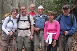
SUNDAY NO. A1104-588 Dec. 4
Coontree Loop extended 9:00 AM
(moderate)
Hike 8, Drive 70, 1700 ft. ascent, Rated B-A
Lenny Bernstein, 828-236-0192, lsberns@att.net
P400 We'll hike the Coontree Loop, but extend it by including the Perry Cove and Bennett Gap trails, with a short road walk on FS 477 to connect the two. Second meeting place: Coontree Picnic area at 9:40 AM. Topo: Shining Rock; also NatGeo map #780
The sky was blue when we left Westgate, but gray and threatening by the time we got to the trailhead. However, the weather gods were benevolent and we didn’t have a drop of rain all day. Eleven of us did the hike in the reverse direction from the way it’s described in the hike data base. This replaced a long steep climb up Perry Cove Trail with a shorter, somewhat less steep climb up Bennett Gap Trail. It also let us begin the hike along Coontree Creek, while we were still in a mood to enjoy the scenery. Even with 1700 ft. of elevation gain, and a number of leisurely stops, we finished the hike in just over four hours, much to the leaders’ surprise. Lenny Bernstein
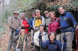 Photo by Danny Bernstein
SUNDAY NO. A1104-310 Dec. 11
Pinnacle Pass - Rim of the Gap *8:00 AM
Hike 9, Drive 80, 1800 ft. ascent, Rated B-A
Jeff McGurk, 864-921-6469, jbsbestfan@hotmail.com
*Form carpools at Westgate, and meet leader at Jones Gap parking lot at 9:00 AM. (Hendersonville hikers form carpools at Cracker Barrel parking lot, NE corner, and leave at 8:30 AM.) Starting at Jones Gap State Park (NOTE: $2 entry fee per person), we will hike a scenic loop route, first hiking up the Pinnacle Pass trail over Little Pinnacle Mountain and taking in two of the best views in the Jones Gap/Caesars Head parks. The way up includes some scrambling over boulders. We will have lunch at the second overlook. Then after back-tracking about a mile we will take a connector trail and return via the Rim of the Gap Trail. Topo: Standingstone Mtn.; also Mountain Bridge Wilderness map
SATURDAY No. A1104-589 Dec. 17
Shut-in Trail & Lake Powhatan loop 10:00 AM
Hike 7, 1200 ft. ascent, Drive 15, Rated B-B
Bob Hysko, cell: 828-243-3630, rhysko@yahoo.com
P400 This will be a shorter version of #589, a loop hike that follows the MST west, then descends Stambaugh Trail, skirts Lake Powhatan and finishes on the Bent Creek Trail. Second meeting place: BRP French Broad Overlook at 10:15 AM. Topos: Asheville, Dunsmore Mtn., also NatGeo. map #780 and Bent Creek Trail Map
SUNDAY NO. A1104-489 Dec. 18
Bad Fork - Trace Ridge Loop 8:30 AM
Hike 8, Drive 60, 2000 ft. ascent, Rated B-A
Becky Smucker, cell: 828-231-2198, bjsmucker@gmail.com
P400 From the Trace Ridge parking area, we will hike a short distance along a gravel road to the Bad Fork Trail, which will take us to the BRP on a steep 800 ft. ascent. From the BRP, we will have a long, steady climb to Ferrin Knob, then down to Beaver Dam Overlook for lunch. After lunch, we continue down the Trace Ridge Trail Topo: Dunsmore Mtn; also Natl. Geo. PRD map # 780
SUNDAY Dec. 25
NO HIKE SCHEDULED - MERRY CHRISTMAS!
----------Half-Day Sunday Hikes----------
HALF-DAY NO. H1104-513 Nov. 27
Craven Gap to Tanbark Tunnel *1:00 PM
Hike 4.6, Drive 6, 900 ft. ascent, Rated C-C
Nonmembers, call leader: Chris and Bonnie Allen, 828-645-0357, chrispallen@me.com
*Only meeting place is at Craven Gap. A pleasant walk in the winter woods along the MST from Craven Gap to Rattlesnake Lodge and down an access trail to the BRP. Topo: Craggy Pinnacle
The Craven Gap to Tanbark Tunnel half-day hike was attended by seven CMC members counting the hike leader. The weather held out nicely for us with no rain, though it was gray and a bit windy. We elected to shuttle to the Tanbark Tunnel end, and hike from there back to Craven Gap rather than the other way around. Everyone enjoyed the hike with fun conversations and no mishaps. Chris Allen
HALF-DAY NO. H1104-534 Dec. 4
Turkey Pen, Pounding Mill, Mullinax Loop *12:30 AM
Hike 6.5, Drive 55, 1200 ft. ascent, Rated B-B
Nonmembers, call leader: Bruce Bente, 828-692-0116, bbente@bellsouth.net
P400 *Form carpools at Westgate, and meet leader at Turkey Pen Trailhead at 1:00 PM. This is a nice winter hike, low elevation and close to Asheville. We'll cross the S. Mills River footbridge, and then do a loop on the scenic Pounding Mill and Mullinax trails. Topo: Pisgah Forest; also NatGero map #780
After an initial panic due to an erroneous report from a resident that Turkey Pen Rd. was washed out (maybe the resident was just trying to reduce the traffic on the road), 13 hikers made it to Turkey Pen Trailhead with no problems, and we did a lollipop hike (loop with a stem). First down the hill to and across the South Mills River bridge, then up Pounding Mill Trail and its 15 stream crossings to Squirrel Gap for a snack break. Then a short distance on Squirrel Gap Trail and down Mullinax Trail back down to the South Mills River Trail and retracing our steps aback to the trailhead. Cool cloudy weather but no rain.
-reported by Bruce Bente
HALF-DAY No. H1104-499 Dec. 11
French Broad River Greenway 1:00 PM
Hike 3.5, Drive 10, 200 ft. ascent, Rated C-C
Nonmembers call Paula Robbins, 828-274-4166, paularww@bellsouth.net
Get a little exercise and view Asheville’s newest greenway. We will walk 3.5 miles from the Hominy Creek Park to the old French Broad River Park. Car Shuttle.
Despite Sunday’s beautiful late autumn weather, only one CMC member arrived for the 3.5-mile walk along the French Broad Greenway. He joined me and a neighbor for a most pleasant stroll on the new paved path overlooking the river along Amboy Road from the bridge to Hominy Creek Park. If members would like directions, I’d be glad to send them. Paula Robbins
HALF-DAY NO. H1104-182 Dec. 18
Green River Cove 11:00 AM
Hike 5.5, Drive 73, 400 ft. ascent, Rated C-C
Nonmembers, call leader: Marcia Bromberg, 828-505-0471, mwbromberg@yahoo.com
Hike Green River Cove trail from bridge to its intersection with the Pulliam Creek Trail, and return on same trail. Enjoy great winter views of the Green River. Although not a lot of altitude gain, there are several short steep uphill sections. Second meeting place: Cracker Barrel, I-26 Exit 53 at 11:30 AM Topo: Cliffield Mountain
SUNDAY HALF-DAY Dec. 25
NO HIKE SCHEDULED - MERRY CHRISTMAS!