----------Wednesday Hikes----------
WEDNESDAY NO. W1104-216 Dec. 14
Sams Gap to Devil Fork Gap 8:00 AM
Hike 9, Drive 90 1900 ft. ascent, Rated A-A
Janet Martin, cell: 502-494-9309, jaykaymartin@msn.com
Follow the AT south from Sams Gap to an overlook at High Rock, and continue to Rice Gap, Lick Rock, Sugarloaf Gap and end at Devil Fork Gap. The ridge along the state line provides views into Tennessee and North Carolina with the south bound hiker actually traveling north. Car shuttle. Topo: Sams Gap
Seventeen hikers enjoyed a clear, sunny day with extensive views. Views of the crest of the Black Mountains and the Roans were especially impressive.
A special thanks to Danny Bernstein for sharing her knowledge about the current forest management program with suppressed burns and the history of the area. Thanks to Tom Sanders for ably serving as sweep. The hike was delightful respite from the holiday bustle. Janet Martin
WEDNESDAY NO. W1104-182 Dec. 21
Green River Cove Trail 9:00 AM
Hike 6.7, Drive 73, 1000 ft. ascent, Rated C-B
Marcia Bromberg, 828-505-0471, mwbromberg@yahoo.com
This is a scenic winter hike along the lovely Green River. We'll hike to the big rocks in the river at the end of the trail, and return by the same route. This hike includes a few steep, but short uphills. Second meeting place: Cracker Barrel at Exit 53 off I-26 at 9:30 AM. Topo: Cliffield Mtn.; also Green River Gamelands Map
WEDNESDAY NO. W1104-589 Dec. 28
Shut-in Trail & Lake Powhatan loop 10:00 AM
Hike 7, Drive 15, 1200 ft. ascent, Rated B-B
Bob Hysko, cell: 828-243-3630, rhysko@yahoo.com
P400 This will be a shorter version of #589, a loop hike that follows the MST west, then descends Stambaugh Trail, skirts Lake Powhatan and finishes on the Bent Creek Trail. Second meeting place: BRP French Broad Overlook at 10:15 AM. Topos: Asheville , Dunsmore Mtn. , also NatGeo. map #780 and Bent Creek Trail Map
WEDNESDAY NO. W1201-749 *Jan. 4
Haywood Gap & proposed Wilderness Extension 8:00 AM
(Mountain Treasures hike #6)
Jill Gottesman, cell: 828-545-5236, jill_gottesman@tws.org.
Hike 8, Drive 70, 2000 ft. ascent, Rated, B-A
P400 *Form carpools at Westgate, and meet leader at entrance to Sunburst Campground on NC 215
at 9:00 AM.: Wilderness area, limit 10, so contact leader for reservation. From the
Sunburst Campground trailhead hike we will hike south on an old gated FS road through wildlands adjacent to the
Middle Prong Wilderness that The Wilderness Society has named a 'Mountain Treasure' area that should be added
to the current protected Wilderness, then left onto the Haywood Gap Trail and hike through the designated Wilderness
to lunch at Haywood Gap. We will return via the same route. Highlights are views at Haywood Gap and scenic streamside
trails through a Wilderness Area much lesser known and visited than its Shining Rock neighbor.
WEDNESDAY NO. W1201-001 Jan. 11
Case Camp - Seniard Ridge Loop 8:30 AM
Hike 8, Drive 80, 2000 ft. ascent, Rated B-A
Mary Beth Gwynn, 828-545-6487, mbgcmc@gmail.com
P400, WC100 This loop hike is scheduled for our coldest month to see 50-ft. frozen cascades along the
closed BRP. We'll do a two-mile climb up to the MST and some gentle MST hiking before our lunch spot
with great views of the mountains. After lunch, we'll hike downhill through beautiful woods on the Seniard
Ridge trail. Second meeting place: Pisgah Forest Bi-Lo at 9:05 AM. Topo: Shining Rock; also pg. 36-39 of
MST Trail Profiles book and Nat.Geo. map #78
To those of you who considered going on today’s hike, but declined to show up at either meeting place due to weather conditions – Bravo! for your good sense. It would have been miserable, and, dangerous. There are two stream crossings in the last third of the hike that already flooded I am sure, even as I write this morning and there is significant lightning in the Pisgah area.
That having been said, I will be hiking this trail in February, both to enjoy it once more and to remove the pink bow trail markers I left on the scout. If anyone is interested in hiking it with me, send me your email address and phone number and I’ll get in touch with you. My email is mbgcmc@gmail.com.
WEDNESDAY NO. W1201-408 Jan. 18 Wolf Ford-Horse Cove Gap Loop *8:30 AM Hike 9, Drive 70, 1200 ft. ascent, Rated A-B Greg Goodman, greggoodman@bellsouth.net P400 *Form carpools at Westgate, and meet leader at Pisgah Ranger Station at 9:05 AM. This hike takes the S. Mills River Trail to Wolf Ford, then goes left on Squirrel Gap Trail to the Horse Cove Trail to FS 5018 then to the gauging station and the cars. Topo: Pisgah Forest, also NatGeo map #780
----------Weekend Half Day----------
HALF-DAY NO. H1104-182 Dec. 18
Green River Cove 11:00 AM
Hike 5.5, Drive 73, 400 ft. ascent, Rated C-C
Nonmembers, call leader: Marcia Bromberg, 828-505-0471, mwbromberg@yahoo.com
Hike Green River Cove trail from bridge to its intersection with the Pulliam Creek Trail, and return on same trail. Enjoy great winter views of the Green River. Although not a lot of altitude gain, there are several short steep uphill sections. Second meeting place: Cracker Barrel, I-26 Exit 53 at 11:30 AM Topo: Cliffield Mountain
Although the day started out quite chilly, by the time the 15 hikers got down into the Green River cove the bright sun had warmed the south-facing trail. We hiked to a lunch spot by the river then continued on to the hike turn-around point at the intersection with the Pulliam Creek Trail where hikers enjoyed cookies provided by the hike leader. By the time we started back most hikers had shed jackets and sweaters. A special treat was having Stu English join us for his return to CMC hiking! Marcia Bromberg
SUNDAY HALF-DAY Dec. 25
NO HIKE SCHEDULED - MERRY CHRISTMAS!
SUNDAY HALF-DAY 	Jan. 1
NO HIKE SCHEDULED - NO HIKE LEADER AVAILABLE

HALF-DAY NO. H1201-623 	Jan. 8
Old Fort to Kitsuma Peak	12:00 PM
Hike 6, Drive, 60, 1800 ft. ascent, Rated C-A
Nonmembers, call leader: Renate Rikkers, 828-298-9988, rerikkers@aol.com
This popular but somewhat strenuous hike begins near Old Fort and ascends Young's Ridge to Kitsuma Peak,
overlooking and continuing on to Ridgecrest. Outstanding views along the way. Car shuttle. Second meeting
place: Ingles parking lot at Exit 64 of I-40 at 12:20 PM.  Topos: Old Fort, Black Mtn.

HALF-DAY NO. H1201-320	Jan. 15
Swannanoa River Stroll to Old Farm School Rd.	*12:30 PM
Hike 5, Drive 12, 100 ft. ascent, Rated C-C
Nonmembers, call leader: Bobbi Powers, 828-667-5419, bobbipowers@live.com
*First meeting place: Folk Art Center back parking lot. This in-and-out hike begins at Owen Park and follows the
Swannanoa River to Old Farm School Road, returning to the park. We will see the Warren Wilson College farm, a
stand of giant bamboo, and enjoy the scenic river. Second meeting place: Charles D. Owen Park at 12:50 PM.
Topo: Oteen; also Warren Wilson College Trails Map

    Cloudless blue sky + 45 degrees + LOTS of water in the Swannanoa River + 20 hikers =
a very pleasant way to spend a winter afternoon!  Bobbi Powers

----------Weekend All Day----------
SUNDAY NO. A1104-310 Dec. 11 Pinnacle Pass - Rim of the Gap *8:00 AM Hike 9, Drive 80, 1800 ft. ascent, Rated B-A Jeff McGurk, 864-921-6469, jbsbestfan@hotmail.com *Form carpools at Westgate, and meet leader at Jones Gap parking lot at 9:00 AM. (Hendersonville hikers form carpools at Cracker Barrel parking lot, NE corner, and leave at 8:30 AM.) Starting at Jones Gap State Park (NOTE: $2 entry fee per person), we will hike a scenic loop route, first hiking up the Pinnacle Pass trail over Little Pinnacle Mountain and taking in two of the best views in the Jones Gap/Caesars Head parks. The way up includes some scrambling over boulders. We will have lunch at the second overlook. Then after back-tracking about a mile we will take a connector trail and return via the Rim of the Gap Trail. Topo: Standingstone Mtn.; also Mountain Bridge Wilderness map
SATURDAY No. A1104-589 Dec. 17 Shut-in Trail & Lake Powhatan loop 10:00 AM Hike 7, 1200 ft. ascent, Drive 15, Rated B-B Bob Hysko, cell: 828-243-3630, rhysko@yahoo.com P400 This will be a shorter version of #589, a loop hike that follows the MST west, then descends Stambaugh Trail, skirts Lake Powhatan and finishes on the Bent Creek Trail. Second meeting place: BRP French Broad Overlook at 10:15 AM. Topos: Asheville, Dunsmore Mtn., also NatGeo. map #780 and Bent Creek Trail Map
SUNDAY NO. A1104-489 Dec. 18 Bad Fork - Trace Ridge Loop 8:30 AM Hike 8, Drive 60, 2000 ft. ascent, Rated B-A Becky Smucker, cell: 828-231-2198, bjsmucker@gmail.com P400 From the Trace Ridge parking area, we will hike a short distance along a gravel road to the Bad Fork Trail, which will take us to the BRP on a steep 800 ft. ascent. From the BRP, we will have a long, steady climb to Ferrin Knob, then down to Beaver Dam Overlook for lunch. After lunch, we continue down the Trace Ridge Trail Topo: Dunsmore Mtn; also Natl. Geo. PRD map # 780
The ten of us were a little worried in the early morning that it would be a windy day, but the breezes died down and we warmed up as soon as started climbing up Bad Fork Trail. Almost no one was out but us and two or three birds, so we felt we had the world to ourselves. As we skirted the northeast side of Ferrin Knob, the still-frozen leaves crunched underfoot, and the air was so clear that we could identify individual buildings in downtown Asheville. It was lovely at the top of Ferrin Knob, so we decided to have a leisurely lunch there instead of at Beaverdam Gap. Without any hurry we were back to our cars before well before 2:00, feeling relaxed and still energetic. If we'd had one extra hour, we might have done it again! Becky Smucker
SUNDAY Dec. 25
NO HIKE SCHEDULED - MERRY CHRISTMAS!
NEW YEARS DAY NO. A1201-281	Jan. 1
Green River Gamelands 	*8:00 AM breakfast, 9:15 AM hike
Hike 6.5 or 8, Drive 70, 1300 or 1500 ft. ascent, Rated B-B
Bruce Bente, 828-692-0116, bbente@bellsouth.net
*Form carpools at Westgate and meet leader at times above at the NE corner of the
Cracker Barrel parking lot in Hendersonville (I-26 Exit 53). After breakfast, we'll do
our traditional New Year's Day hike on a series of trails around the Green River
Gamelands. We'll hike down to and along the Green River, with a late lunch at the big
rocks on the Green River, and then hike up and out on the Pulliam Creek trail. Short car
shuttle.  Topo: Cliffield Mtn.; also Map of the Green River Gamelands Trails

    About twelve hikers gathered for breakfast at Cracker Barrel and we warmed ourselves
at a table by a roaring fireplace.  Eight more hikers joined us afterwards for our traditional
hike in the Green River Gamelands, starting at 2000' and descending 900' to the Green River.
On this sunny day, it warmed quickly and outer jackets were shed quickly as the temperature
eventually got up to 60 degrees.  Lunch for most of us was at the big rocks on the river, where we
soaked up the sun and were entertained by a half-dozen kayakers.  On the way out on Pulliam
Creek Trail, we saw more kayakers way below us as they came through the Gorilla rapids. Many
thanks to the CMC maintenance crew for rebuilding the bridge at the end of the hike.
Reported by Bruce Bente

Case Camp – Seniard Ridge Loop 8:30 AM
Hike 8, Drive 80, 2000 ft. ascent, Rated B-A
Mary Beth Gwynn, 828-545-6487, mbgcmc@gmail.com
P400, WC100 This loop hike is scheduled for our coldest month to see 50-ft. frozen
cascades along the closed BRP. We'll do a two-mile climb up to the MST and some
gentle MST hiking before our lunch spot with great views of the mountains. After lunch,
we'll hike downhill through beautiful woods on the Seniard Ridge trail. Second meeting
place: Pisgah Forest Bi-Lo at 9:00 AM. Topo: Shining Rock; also pg. 36-39 of MST
Trail Profiles book and NatGeo. map #780
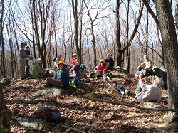
There were 14 hikers on Sunday, 6 from Charlotte! Although the day was
cooler, wetter and more overcast than Friday’s scout, it was still an enjoyable
day. Remnants of ice remained on the walls. At our lunch break everyone, except
the leader who enjoyed a few minutes of quiet time, hiked further up the BRP to
GPS an additional mile. They saw more ice formations on that section. If the hike
runs again on Wednesday 1/11/12 as planned the leader will offer that as a
lunch-time option.
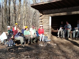
SATURDAY NO. A1201-743	Jan. 14
Pressley Cove to Pisgah Ranger Station 	*10:00 AM
Hike 6, Drive 70, 1250 ft. ascent, Rated C-B
Ashok Kudva, ashok.kudva@att.net, 828-698-7119, cell: 828-674-1374
P400  *Organize carpools at Westgate, and meet leader at Pisgah Ranger Station at
10:35 AM. We will start with a steep climb on Pressley Cove trail, with two stream
crossings via footbridges, to an old homestead chimney and join the Black Mountain
Trail via an old logging road. After a short climb to Hickory Knob, it is all downhill to
the Pisgah Trail Maintenance Station and a 100 yard walk to the Exercise Trail at the
Ranger Station. Short car shuttle.

  Only one hiker, a non-member, joined me on a cold (27F), sunny day when
 wind was calm and conditions were ideal for the hike.  After his first CMC
 hike, he became very enthused about joining us to participate in hikes and
 trail maintenance. I provided him with the latest Let's Go and an
 application form. Photo by Jim Bailey


SUNDAY NO. A1201-438	Jan. 15
Rich Mountain, Round Top Trail and Lovers Leap	8:30 AM
Hike 9.5, Drive 70, 2200 ft. ascent, Rated A-AA
Tom Sanders, 828-252-6327, tomary.avl@gmail.com
LTC  From Tanyard Gap we will go north on the AT to the beautiful views from Rich
Mountain, then descend to Hot Springs via Round Top Ridge Trail, culminate the day
with a short climb to Lover's Leap, and finish on the AT in Hot Springs. Second
meeting place: Tanyard Gap at 9:15 AM. Car shuttle.  Topo: Hot Springs; also FS
Hot Springs Harmon Den map; NatGeo map # 782
SUNDAY NO. A1201-438 Jan. 15
Rich Mountain, Round Top Trail and Lovers Leap 8:30 AM
Hike 9.5, Drive 70, 2200 ft. ascent, Rated A-AA
Tom Sanders, 828-252-6327, tomary.avl@gmail.com
LTC From Tanyard Gap we will go north on the AT to the beautiful views from Rich
Mountain, then descend to Hot Springs via Round Top Ridge Trail, culminate the day
with a short climb to Lover's Leap, and finish on the AT in Hot Springs. Second
meeting place: Tanyard Gap at 9:15 AM. Car shuttle. Topo: Hot Springs; also FS
Hot Springs Harmon Den map; NatGeo map # 782
Thirteen of us started the 9.5 mile hike around 10:00 A.M. from Tanyard Gap northbound on the AT and, then, the spur trail up to the Rich Mountain fire tower where the 360 degree views were spectacular as usual as we took our lunch break. After lunch, we headed southbound on the AT and picked up the Round Top Ridge Trail which provides lots of mountain views through the woods during the winter. We exited that trail on River Road in Hot Springs and walked along the the very full and rushing waters of the French Broad River down to Silvermine Road and picked up the Lovers Leap Trail and headed up to Lover's Leap. We headed southbound on the AT along the scenic river (no usual Canadian geese perched on the river rocks this time as all rocks were covered with rushing water) back to our Silvermine Road shuttle parking area with an arrival time of 3:30 P.M. It had snowed the evening before, but, it was a very pleasant hike since the day turned out to be sunny instead of the forecasted Sunday snow flurries for this NC/TN area. Tish Desjardins